Mississippi River
Started on the Mississippi River this morning, Tues., Sept. 3. Illinois is on our left (hilly at this point) and Missouri (quite flat here) is on our right. It’s a cloudy day, so tough for picture taking, but even the silhouettes are telling.


We left with “Delta Blues,” “Checkmate,” and “2nd Chance.” On the way, we met up with “Patti Anne” and “Til You Can’t” who had both stayed in Alton (further up from Grafton) for the night. On the Mississippi, we have to watch for wingdams and weirs, stone walls running at an angle from shore into the river. Their purpose is to prevent erosion of the river banks by creating a self-flushing that helps to curtail shoaling in the channel. Some (weirs, I guess? It seems the terms are used interchangeably) are completely or partially underwater (like the one below we saw on Wed.) …

… allowing the water to flow over them while others (wingdams?) are quite visible (as shown below). However, these may not be visible in the much higher water levels that occur. So, perhaps they are then weirs??


You can also see the piles of logs and sticks (above). We are constantly on watch for floating debris that can harm the boat by catching in the propellor or rudder shaft. Like icebergs, only a small portion of the object can be seen on top of the water. We alert one another on an agreed-upon VHF channel as to when we see floating objects and where in relation to the boat they are. Below is an example of a marine polypropylene line used on tows/tugs that when in the water can also foul propellors.

The wingdams are noted on the electronic charts by straight black (or blue on third) lines.


We had to maintain station for quite a while today before we were able to lock through one chamber of the Mel Price Locks. The first of the two locks we’ll do on the Mississippi, it is quite large with two chambers, one 110 x 1200 and the other 110 x 600. Evidently, 30 percent of the world’s grain passes through Mel Price Locks and Dam.

The current on the Mississippi is much stronger than that of the Illinois. It runs between 2.5 to 4 knots as opposed to the Illinois which is more like .5 knots. We make very good time, as the current is helping us along! Maneuvering into the lock here was tricky, as a barge was leaving, so you had current plus his wake rebounding off the walls.
Passed a dry dock for barges.

The second set of locks through which we traversed today was called “Chain of Rocks Locks and Dam,” a curious name until we experienced the channel leading to the locks. It is one very long “chain” of rocks.


We’d been cautioned in the briefing at Heritage Harbor to not “for the love of God” go right at the junction to the Chain of Locks channel, as the other channel descends into rapids where many boats have had to be salvaged because they were destroyed. Not to worry, as “here’s your sign.”

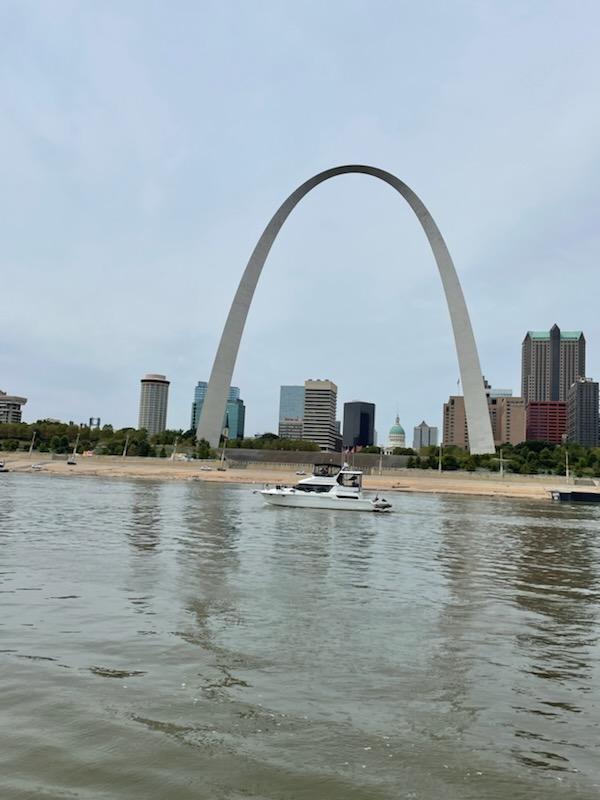
As soon as you exit the Chain of Rocks Lock, you can see St. Louis.


Here is Exodus passing the arch.
Made it to Hoppie’s late afternoon which is the last stop for fuel for the next 200+ miles. It’s just the very, very basics, but we were all glad to see it. On left below, “Til You Can’t” is getting fuel and on right “Delta Blues” is secured to the inside of one barge.


After fueling, we ended up on the outside of that barge, behind the “Patti Anne.”


Hoppie’s daughter met us on the barge at 5:00pm and offered a briefing about water depths, etc., from here to Green Turtle Bay in KY.
Leaving Hoppie’s on Wed., Sept. 4, we had Missouri on our right and Illinois on our left again, but this time, Missouri had the cliffs. The Mississippi, in this area at least, is much more rural than the Illinois.

We traveled to the Kaskaskia Lock and Dam, on the way seeing large sandbars …

… and experiencing some turbulent waters.

Because the Mississippi is deeper than the Illinois, you experience more turbulence as well as the occasional whirlpool.
We didn’t lock through the lock that serves the KasKaskia River (a tributary of the Mississippi), only tied up for the night on the wall. While there are no services (electricity/water), it is a safe place to spend the night out of the Mississippi. We were tied to the other side of the jetty where the tows and barges pass after locking. Picture on left below shows the other five boats with which we were traveling (i.e., “Delta Blues,” Til You Can’t,” “2nd Chance,” “Bo-lin,” and “Patti Anne.”) Our boat is closest to the lock.


The jetty actually floats to accommodate the fluctuation in river depth, the tall structures vertical supports for the floating jetty. Doug and Barbara (“2nd Chance”) stopped to watch a tow with barges pass through after locking.


Everything you’ve heard about mud on the Mississippi would appear to be true. The water is so muddy that you can’t really rinse the mud off anything, because there is already so much mud and silt in it. Taking the dogs to shore was really a challenge here.
First we tried the “boat ramp” at a nearby park. Someone had dug enough mud out to get perhaps a kayak or canoe through. However, it was too slippery to get out of the inflatable, so no go there.

Ended up on the shoreline further down. Wet mud at shoreline but dry, cracked fields of it higher up, resembling a desert.


Left the Kaskaskia Lock and Dam Thursday, Sept. 5, making our way further down the MIssissippi. We received a call from a captain on Channel 13 because he saw us on the AIS. Turns out it was the crusie ship, American Heritage.

Dennis talked to him and said that we had five boats approaching. He said, “Yeah, I see your little flotilla. Are you doing the Great Circle?” He wished us a safe journey and instructed us to take him on the 2. Our group received a steamship whistle salute.
Also passed a half-buried tugboat …

… and what is called, Tower Rock, a kind of interesting formation in the middle of the bank.

We anchored Thursday evening in “Little Diversion,” a small inlet …

… off the Mississippi near Cape Girardeau. Like some of the other towns we’ve seen, Cape Girardeau has a wall built to prevent flooding. The bridge nearby shows the water line of what is probably more average depth vs. current low water or possible flood levels


We anchored with the same five boats …

… and met some of the boaters at the sandbar across the river when walking the dogs. Nelson was in his glory, running through the water and splashing us all then running circles on the sand. Even Ivy waded in. Freedom!


John, the man in the middle wearing a yellow tee, was hit in the back on the ride over by an Asian carp then one flew into their inflatable!
Picture from the sandbar of our last day on the Mississippi.

Will enter the Ohio tomorrow (Friday) and say goodbye to the Mighty Mississippi.