The Chesapeake (MD, DE), continued
On this sunny Tues., May 17, we walked to breakfast at the Blackwater Bakery in Cambridge where we ran into Loopers Kate and Andrew (“Tortuga”). Later, we did some further exploring of the area with the inflatable, including a closer look at the lighthouse …

… and a view of the J.M. Clayton Seafood Company dock near us. This company, founded in 1890, is the oldest working crab processing plant in the world. One after another crab boat passes our marina to come in to this dock (pictured below) to unload its harvest.


Numerous crab boats such as the one pictured below dock at this city marina, perhaps accounting for the sign in the below second picture.


The watermen use trotlines (long lines with baited hooks) that they anchor in the water. The orange floats on the boat in the picture mark a line’s location. The harbor is busy with crab boats around the clock.
Cambridge itself is probably a little busier than usual right now, as the hydroplane races are taking place May 16-18. From our boat, we can watch the cranes lifting the specialized boats into the water to race.
Also nearby is the Pride of Baltimore II, a reproduction of a 19th-century topsail schooner.

Here are some other sights from Cambridge, including a beautiful Magnolia blossom as well as a stack taken off the USS Potomac inside of which is the elevator that carried FDR when he was aboard.


The winds are strong here, so much so that the second day of the hydroplane race got cancelled. We made the best of it by biking for a few provisions, taking care of several chores, and enjoying some tasty French toast one morning.


It turned quite cold and rainy for several of the days we spent in Cambridge. The ducks seemed at home, however.


A very kind sail boater that met us when we first arrived offered twice to take us to a grocery store, and we took him up on it on Wed., May 21. We were so grateful, as we could only find small items in the distance our bikes could take us. His name was Scott, and the boat’s name was “Booger.” Yes, there’s a story.
Ultimately, we stayed in Cambridge, MD, for nine nights, one of our longest stays on the Loop. As noted in the previous blog entry, while in Cambridge we experienced a rare late-May Nor’easter that impacted our ability to travel. As part of that whole weather event, on Thurs., May 22, we watched as a hail storm hit, a loud episode on a boat!

After the hail storm, some intrepid vendors at the small, nearby farmer’s market opened for business. Dennis ordered the advertised crab balls. Evidently, they’re kind of like hush puppies but with crab.


On Saturday, May 24, the weather cooperated, and we were very happy to welcome Nathan, Kim, Thomas, and Katherine for a visit to the boat. We got to catch up further over a good brunch in town, and it was wonderful to see them!

That evening, several Loopers gathered for docktails, including Mike and Pam (“Thyme Away”), Scott and Dawn (“Flew-the-Coop”), and Skip and Linda (“Dream Lady”).

The next morning, Sun., May 25, the winds were more favorable, and we left Cambridge for St Michael’s, MD. Heading toward San Domingo Creek behind St. Michael’s, we saw Rusty and Melissa (“Providence”) who told us that there were dozens of sailboats already anchored in the creek where we planned to anchor. When we arrived, we found that they were accurate! The anchorage was full, but we were able to find a spot (first picture below), albeit quite far from the dinghy dock (second picture) in town.


The town of St. Michael’s is a popular spot for tourism.

We highly recommend JoJo’s ice cream. As you can see from the picture below, it’s a clear favorite.

St. Michael’s has some unique signage.


While in St. Michael’s, we visited the Chesapeake Bay Maritime Museum. The entrance to the museum sports the original drawbridge that once connected Tilghman Island to the rest of the world.

A good deal of the museum was devoted to the work of the watermen who harvested oysters and crabs, including blue crabs which are a delicacy. Visitors are permitted to board and explore a couple of boats on display in the museum. An oyster boat …

… and a 1960’s era Owens cabin cruiser similar to the one Dennis’s family owned when he was a kid.

Like the Drum Point lighthouse we saw at the Calvert Museum in Solomons Island, the Hooper Straight Lighthouse (bult in 1879) featured at this museum (first picture below) is also a screw-pile lighthouse. A screw like the one pictured below (second) is at the end of each of the seven pilings (or legs) of the lighthouse. These were twisted into the bottom of the Chesapeake Bay on an angle which gave the structure a more stable foundation.


Before leaving St. Michael’s, we learned that not all crab fishermen work from crab boats. Here is an enterprising guy that we saw toiling for hours catching crabs using what appeared to be a modified fishing kayak.

It must be that oyster fishing is still popular, as well, because there were beds for lease such as the one advertised in the below photo.

Weighing anchor on Tues, May 27, took a while, as we had to hose a great deal of mud off the anchor chain that had been sitting on the muddy bottom. Today we plan to take what I’m calling the “Tilghman Island Challenge.” To get out into the Bay from here, you have to go west, but Tilghman Island is in the way. You can go south around the point, which takes time and fuel or you can take the Tilghman Island cut which is faster but reportedly very shallow in spots. An added bonus to saving time by taking the cut is inexpensive diesel fuel at Fairbank Tackle – if you’re willing to try to get to the self-serve pump without a dock (just pilings) that caters to commercial watermen!
We took the challenge. Here is the waterway coming into the island.

Once we were able to back between the (just two) very narrow pilings – all the while avoiding the conveyer belt sticking out at an angle from the crab boat next to us (first picture below) – the next challenge was how to get off the boat to pump fuel (second picture).

Note the lack of a dock. Dennis had to balance on the (unsupported) edge of the inflatable and stretch a leg to land. Then, he repeated the process while gripping the fuel hose.

The experience was made even more interesting by the name on this waterman’s boat docked near us during all of this.

The whole enterprise wasn’t over until we were able to successfully traverse the narrow and shallow channel leading through to the other side of Tilghman Island and out into the Chesapeake. It was high tide but ebbing. Doing our best to abide by the markers, we breathed a collective sigh of relief when we passed through the lowest points and saw the Bay! Challenge complete.
Our next step was to cross under the Chesapeake Bay Bridge which connects Annapolis to Kent Island.

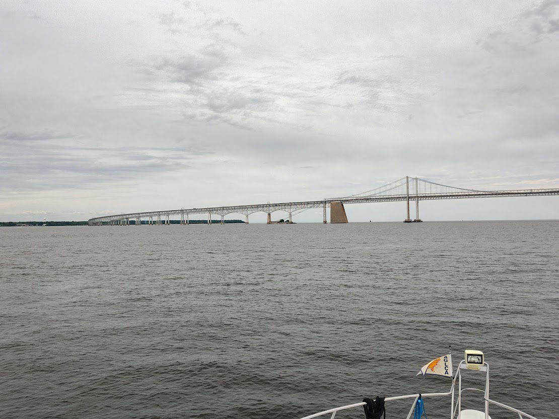
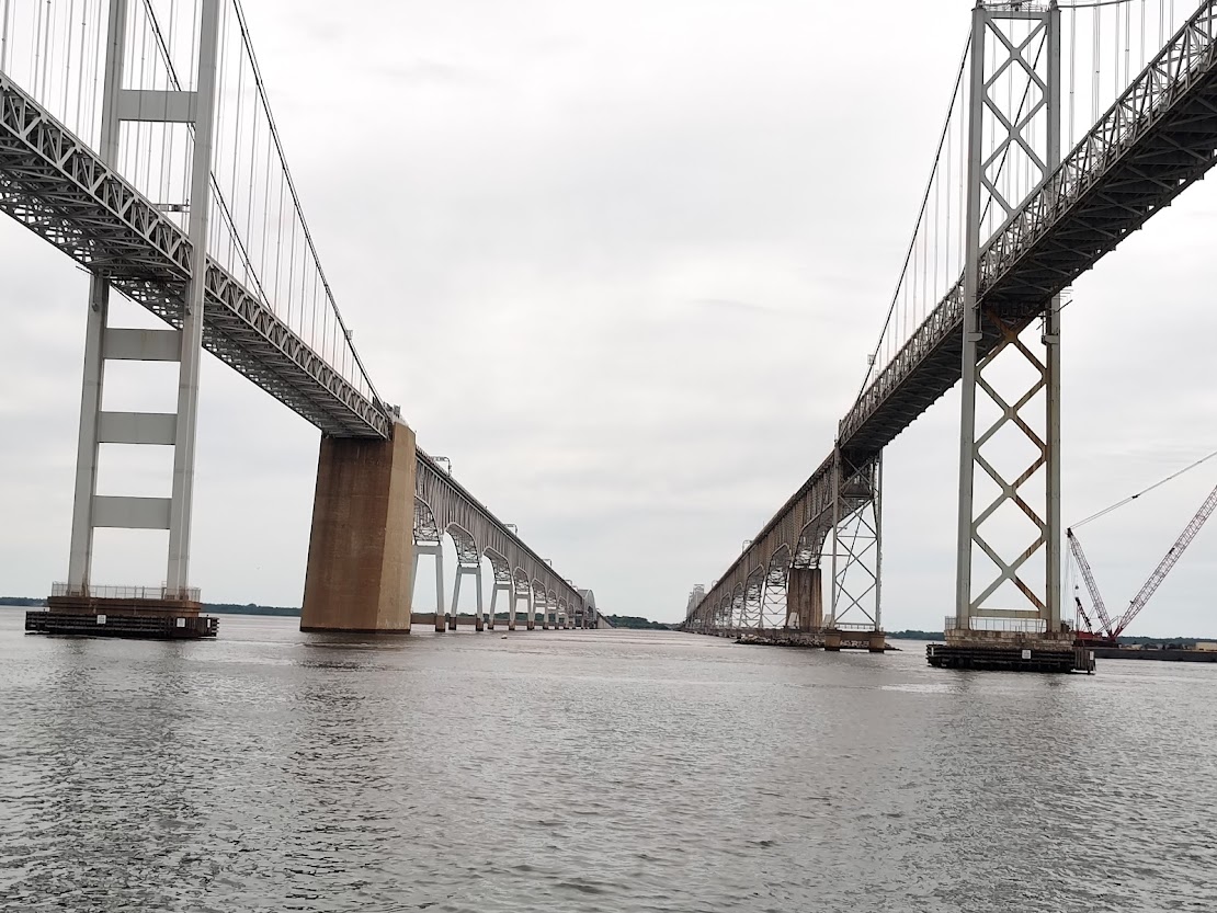
We were grateful for the calm, though cloudy, day to travel on the Chesapeake as we made our way to Rockhall, MD.
Rockhall Landing Marina is a really nice little establishment that also has a motel, pool, bike rental, firepit, and lots of gathering areas.


They’ve really done an admirable job with making this a pleasant getaway. Maybe it’s one of the reasons that Rockhall is called the “Pearl of the Chesapeake.” Here are a few pictures of shops downtown, one you might recognize!


It rained buckets while we were in Rockhall, unfortunately, making chores like laundry (at the machines in the outdoor, covered patio near the motel) as well as dog walking a very soggy experience. We had to pick up a prescription at Walgreen’s also, so we tried to take that walk at the least damp time!
Leaving Rockhall on Thurs., May 29, we experienced one-foot waves in the Bay. Passing Aberdeen Proving Ground, where a patrol boat was running with flashing red lights, we heard several loud booms. The water calmed down a bit as we continued and eventually entered the C and D Canal. Below are a couple pictures from the first part of the day.


Our aim that day was Chesapeake City, but there was no room on the wall by the time we arrived, so we pushed on to Delaware City where we were headed the following day anyway. The Harbor Host at Delaware City and Curtis Stokes & Assocs. (boat brokerage) are sponsoring a gathering there for Loopers who are finishing the Chesapeake and wish to find out about traversing Delaware Bay to Cape May, NJ.
You could see the nuclear power plant for some time while we were in the C and D Canal, and as soon as we exited the Canal, we saw several tugs and barges and container ships.

The wind picked up considerably when we entered the Delaware River. On the way we met this ship.

We followed the directions from the marina very closely, as there was no room for error in the narrow waterway. Once we docked, the workers there “swung” us. Because of the severe current and tide in this waterway, the marina dockhands swing all boats manually using the current to help turn the boat so that when you are ready to leave, your bow is pointed out of the canal. Kate and Andrew (“Tortuga”) stopped by later to ask us to dinner, but we’d already eaten by that time.
The next morning, Fri., May 30, several boaters decided to leave before the briefings so as to use today’s favorable weather window to cross Delaware Bay. Chuck and Kim (“Til You Can’t”) arrived today, and we visited with Christine and George (“Resonance”) as well. At one point in the day, poor Nelson miscalculated the distance from the swim platform to the shore and took an unexpected swim!
While at Delaware City, we attended the nightly briefings, joined the group for dinner at Kathy’s Crab House, and toured the small downtown. We had a chance to meet and visit with multiple Loopers, including Mike and Marguerite (“Alba”) and Gerry and Tiffany (“Bobbin Along”) among many others.


Dennis visited Fort Delaware.


Here is a picture of us once again breaking a law, this time by having a bike on the sidewalk (boat in background).

We tried to keep up with Chuck and Kim on a bike tour with promised ice cream at the destination, but I pooped out early. We returned and just got some treats from the marina!

The tide swings are substantial here, and the following set of pictures helps to illustrate low tide to high tide.


One of the objectives of the briefings is to try to determine the best weather and tide windows within which to cross Delaware Bay to Cape May. In addition to the Harbor Host’s briefings, we were treated to an additional, impromptu briefing by Mick (“Phantom”) who has done the Loop seven times!
We were going to leave on Sun., June 1, but decided against it given the winds. Instead, we left very early on Mon., June 2, as did nearly every other boat in the marina. To give you an idea of the strength of the tidal current, we were going 12 knots though running at idle speed!
We passed from the Delaware River to the Delaware Bay where there is much more fetch given the Bay’s width (i.e., there is much more space for wind to kick up waves). Furthermore, we had a contrary current to tide issue; the tide was changing from ebbing to flood and flowing opposite of the current.
We reached Cape May, NJ, early, as we’d given ourselves plenty of wiggle room. The next entry will follow Exodus motoring up the New Jersey coast in the Atlantic Ocean.